Southern Iraq is the part of the country I find hardest to describe and easiest to love. This is the deep south — Basra’s palm-lined waterways, the vast reed wetlands of the Mesopotamian Marshes, and the 5,000-year-old Sumerian cities where writing, cities and the wheel were arguably invented. It is the literal cradle of civilization, and almost nobody goes.
If you want the short version: a trip to southern Iraq usually means flying or taking the night train to Basra or driving down to Nasiriyah, then splitting your time between the UNESCO-listed marshes around Chibayish, the ancient ruins of Ur, and the riverside cities of Basra and Al-Qurnah. It is hot, raw, deeply hospitable, and unlike anywhere else on earth. You’ll want a guide or fixer for the marshes, and you should go in the cooler months.
This guide is the southern hub of our complete Iraq travel guide, and I’ve written it as the regional companion I wish I’d had: an honest, opinionated walk through everything the south holds — the marshes and the people who live in them, Basra and its food, the Sumerian sites, the practical business of getting there and staying safe — and the parts the glossy listicles leave out. Southern Iraq rewards the traveler who plans properly and arrives with realistic expectations, so let’s set those properly.
Southern Iraq at a glance
The south breaks down into four building blocks, and most trips combine two or three of them. Here’s the orientation I give friends before they plan a route — what each place is, why you’d go, how long it needs, and when.
| Place | What it is | Why go | Time needed | Best season |
|---|---|---|---|---|
| The Mesopotamian Marshes (Chibayish) | UNESCO wetlands, reed islands, water buffalo | The single most unique experience in Iraq | Half-day to overnight | Nov–Mar |
| Ur & ancient Sumer (near Nasiriyah) | The great ziggurat and the world’s first cities | The cradle of civilization, walkable ruins | 2–3 hours | Oct–Apr |
| Basra | Southern port city on the Shatt al-Arab | Riverfront, food, dates, “Venice of the East” | 1–2 days | Nov–Mar |
| Al-Qurnah | Where the Tigris meets the Euphrates | The legendary “Garden of Eden” tree | 1–2 hours (from Basra) | Nov–Mar |
A few honest framing notes before we go deeper. This is the hottest region in one of the hottest countries on earth — Basra holds Iraq’s all-time temperature record of 53.9°C (129°F), so the practical visiting window is roughly November to March, and high summer is genuinely dangerous. The marshes are the headline act, and they’re recovering from a brutal multi-year drought (much more on that below). And the whole region carries the same serious safety caveats as the rest of Iraq: Western governments advise against all travel here, which I’ll cover honestly next. Most foreigners who visit the south do it with a local guide, and I’d recommend you do too — it solves transport, language, the marsh logistics and the checkpoints in one move. For the wider picture of what else the country holds, our best places to visit in Iraq guide puts the south in context.
Is southern Iraq safe to visit?
I’ll give it to you straight, because trust is the whole point of this site. As of mid-2026, every major Western government advises against travel to southern Iraq. The U.S. State Department has Iraq at Level 4 — Do Not Travel, and in March 2026 it ordered non-emergency government staff to leave the country. The UK Foreign Office (FCDO) advises against all travel to Federal Iraq, including the south, citing the regional conflict that has flared repeatedly through 2025 and 2026. These advisories are real, they affect your travel insurance, and you should read them yourself before deciding — our honest Iraq safety guide goes region by region and is updated as things change.
Here’s the on-the-ground nuance those headlines miss. The south is not an active war zone, and a steady trickle of independent travelers and small tour groups has been visiting Basra, Ur and the marshes for years without incident. The day-to-day risks are less about violence aimed at tourists and more about regional instability you can’t control (airspace closures, flare-ups tied to the Iran–Israel conflict), the militia and tribal dynamics of the deep south, the checkpoints you’ll pass through constantly, and the sheer environmental hazard of the heat. Anti-Western sentiment can run higher in parts of the south than in, say, Kurdistan, which is one more reason a local guide who knows the area is worth every dinar.
The honest bottom line: southern Iraq sits firmly in “experienced, risk-aware traveler with a guide” territory, not “first solo trip abroad” territory. If you’re new to the country, many people start with the calmer, more developed Kurdistan Region and work south later. Whatever you decide, go in with eyes open, keep your visa and paperwork in order, build flexibility into your plans, and re-check the advisories and airspace status close to departure — this is a fast-moving picture.
The Mesopotamian Marshes: the soul of the south
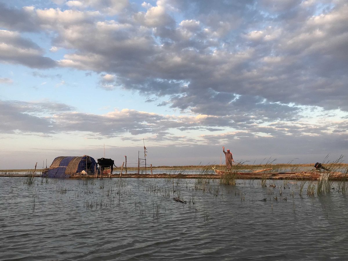
If you make one journey into southern Iraq, make it this one. The Mesopotamian Marshes — the Ahwar — are a watery world of reed islands, narrow channels and water buffalo that has supported human life continuously for five millennia. Gliding out at sunset in a long canoe, past reed houses and herders bringing their buffalo home through the water, is the most extraordinary few hours I’ve spent anywhere in Iraq. It is also a place under real threat, and visiting it thoughtfully matters.
What are the marshes — and the Ahwar UNESCO site
The marshes are a complex of wetlands at the confluence of the Tigris and Euphrates, historically covering something like 20,000 square kilometers — the largest wetland ecosystem in the Middle East. They split into three main areas: the Central Marshes between the two rivers, the Hammar Marshes to the south toward Basra, and the Hawizeh (Huwaizah) Marshes to the east, straddling the Iranian border. This is widely thought to be one of the candidates for the original “Garden of Eden,” and the reed-building culture here is a direct, living link to ancient Sumer.
In 2016, UNESCO inscribed “The Ahwar of Southern Iraq” as a World Heritage Site — and crucially, as a mixed site of seven components: four marsh areas (Central, East Hammar, West Hammar and Huwaizah) plus three of the great Sumerian archaeological cities — Ur, Uruk and Eridu. That single inscription is the reason this guide ties the marshes and the ancient ruins together: UNESCO treats them as one cultural-natural landscape, the place where the world’s first cities rose out of the wetlands. We cover the archaeology in depth in our ancient Mesopotamia guide.
The drought — and the 2026 revival
You need the honest current picture, because it changes what you’ll see. Under Saddam Hussein, the marshes were deliberately drained in the 1990s as retribution after the 1991 Shia uprising — canals and dikes diverted the rivers, and by 2003 roughly 90% of the wetlands had dried to salt-crusted desert, scattering the Marsh Arab population. After 2003 the dikes were breached and the marshes partly re-flooded, a genuine environmental comeback story.
Then came the drought. Between 2021 and 2025, upstream dams in Turkey and Iran, record heat and failed rains shrank the marshes catastrophically again — some areas, including the Ishan Hallab zone sometimes identified with the Garden of Eden, dried out completely, and herders abandoned land their families had worked for generations. For a few years, the romantic “endless wetlands” image simply wasn’t true.
The good news, and the reason 2026 is a better year to visit than the previous few: heavy winter rains in 2025–26 revived the marshes substantially. By spring 2026, the share of submerged marshland had climbed to around 32–36%, up from no more than 8% during the worst of the drought, and Iraq’s water ministry was releasing growing volumes downstream. In Chibayish, canoes are gliding through channels that were cracked mud a year earlier, the buffalo and birds are back, and families have returned. It is a real recovery — but a fragile, partial one that depends on rainfall and on how much water Turkey and Iran release. Go now, but go understanding you’re seeing a recovering ecosystem, not a pristine one.
How to actually visit the marshes
This is the part most articles hand-wave, so here’s the real mechanics. The launch point is the town of Chibayish (Al-Chibayish), on the edge of the Central Marshes, roughly a 90-minute drive (about 90 km) from Nasiriyah. Most people base in Nasiriyah, visit Ur in the morning and the marshes in the afternoon — you genuinely can do both in one day, though an overnight in the marshes is the better experience if you have time.
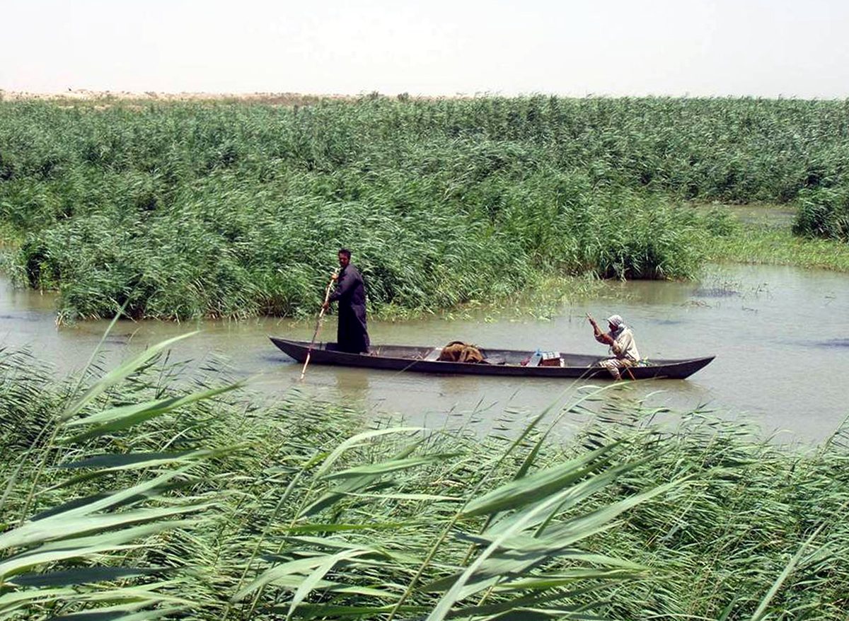
From Nasiriyah, a shared taxi toward Chibayish runs around 5,000 dinars (a few dollars); a private taxi to take you all the way to the boat docks is more like 25,000 dinars. Boats wait near the Martyrs’ Monument in Chibayish, where there’s a small, generally friendly military post. The traditional canoe is the mashoof, these days usually motorized. A two-to-three-hour boat trip out among the reed islands — best timed for late afternoon and sunset — is the standard, and it’s plenty to feel the place.
Guides and pricing are worth understanding so you don’t overpay. The most famous boatman, Abu Haider, is widely reported to charge around 150,000 dinars — roughly three times what others ask — trading on his fame. Plenty of other local guides will take two people out for around 50,000 dinars, and the better-value arrangements bundle a boat trip, lunch, a masgouf dinner, breakfast and an overnight stay in a reed guesthouse into one price. The most reliable way to line this up in advance is through the active “Iraqi Travelers Café” / Iraq travel community groups on Facebook, or simply through whichever guide or driver brought you south. Permits are a grey area — some travelers register briefly with the local police (your host can arrange it), others report no formality at all — and the trend has been toward fewer hassles. Bring cash, bring patience, and confirm what’s included before you push off.
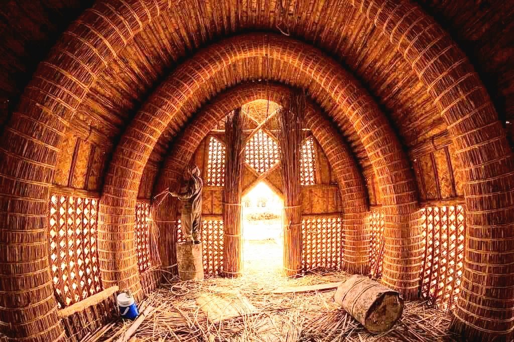
Sleeping overnight in a mudhif — the great arched reed guesthouse — is the experience worth planning a whole trip around. It is basic (mats on a reed floor, not thread counts), but waking to dawn mist over the water, with buffalo lowing and a host pouring you tea, is unforgettable, and your money goes directly to a community that nearly vanished. We cover the homestay logistics and a couple of other one-of-a-kind stays in our where to stay in Iraq guide.
The Marsh Arabs (Ma’dan) and their reed world
You can’t separate the marshes from the people who made them legible. The Marsh Arabs — the Ma’dan, though many prefer “Ahwari” — have lived in these wetlands for thousands of years in a way of life with startling continuity to ancient Sumer: building islands and houses from harvested qasab reeds, herding water buffalo, fishing the channels, and moving everywhere by canoe. The British explorer Wilfred Thesiger immortalized them in his 1964 book The Marsh Arabs, and reading it before you go will deepen everything you see.
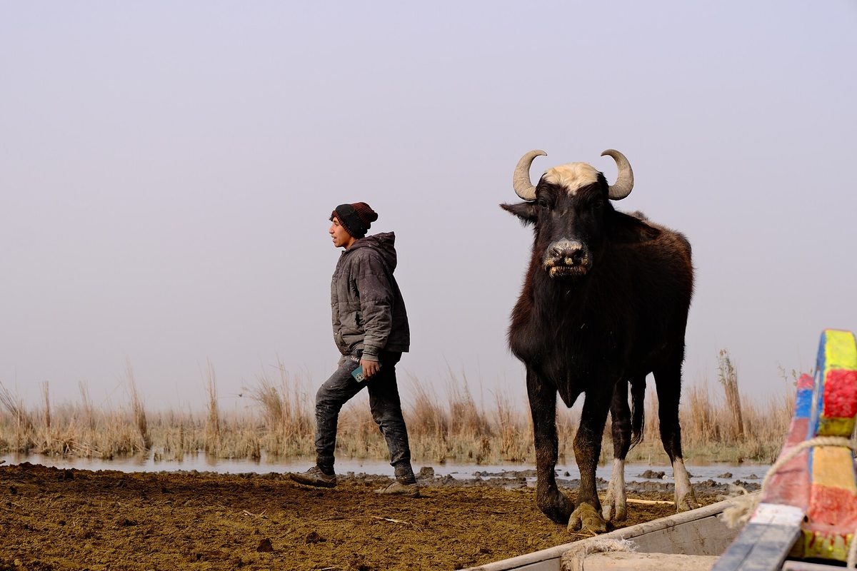
Their recent history is wrenching, and worth knowing as you visit. From perhaps half a million people in the 1950s, the population was gutted by Saddam’s draining of the marshes after 1991 — homes burned, water poisoned, families forced out. Numbers in Iraq fell to as few as 20,000, with tens of thousands of others fleeing to Iran. Since 2003 many have returned and the culture has clawed its way back, though the recent drought displaced people all over again. Reliable figures are genuinely hard to pin down; today’s marsh-dwelling population is best described as tens of thousands, a fraction of its mid-century peak, concentrated in the Dhi Qar, Maysan and Basra governorates. You’ll sometimes hear the Ma’dan described as direct descendants of the Sumerians — the cultural and architectural parallels are real and striking, though scholars treat a literal genetic line as unproven, so I’d frame it as a profound living echo rather than a documented bloodline.
The architecture is the thing that stops you. The mudhif is a large guesthouse built entirely from bundled reeds, its rows of parabolic arches assembled without a single nail or piece of wood — a building technique depicted on Sumerian artifacts five thousand years old. Traditionally a mudhif is the sheikh’s hall, the place where guests are received and disputes are settled, its entrance facing Mecca. Smaller reed dwellings house families, all of it raised on artificial islands of layered reed and mud. Watching a host re-thatch a wall, or pole a slender tarada canoe through a channel, you understand why people call this the oldest continuously inhabited landscape on earth. To go deeper on the customs, hospitality and etiquette you’ll encounter, see our Iraqi culture and etiquette guide.
Basra: Iraq’s southern port and the “Venice of the East”
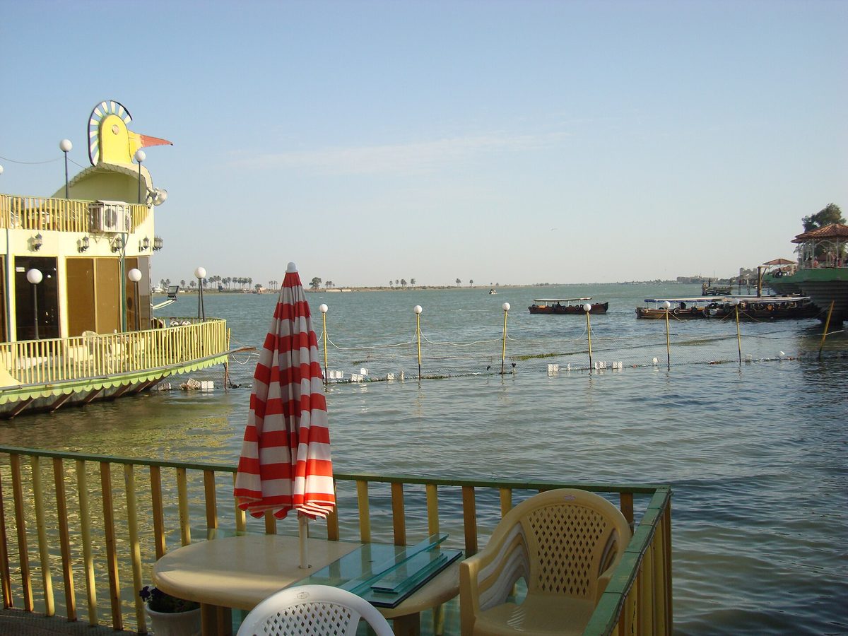
Basra is the great city of the south — Iraq’s main port, its oil capital, and a sprawling, steamy place of around 1.5 million people strung along the Shatt al-Arab waterway. It has a long, romantic literary reputation: the city of Sinbad the Sailor, a historic trading hub crisscrossed by freshwater canals that earned it the nickname the “Venice of the East.” The reality today is more complicated and, in places, more poignant than the postcard — but Basra is absolutely worth a day or two, especially for its food, its riverfront and as the gateway to Al-Qurnah and the southern marshes.
Things to do in Basra
The heart of Basra is the river. The Corniche, the riverside promenade along the Shatt al-Arab, is where the city comes alive in the cool of the evening — families strolling, tea stalls, boats for hire, and the lights of the far bank across the water. A boat ride on the Shatt al-Arab at sunset is the quintessential Basra thing to do; you can usually negotiate one right from the Corniche. Out in the waterway sits Sinbad Island, a leafy park-and-leisure island reached by bridge, dedicated to the city’s seafaring legend.
For history and atmosphere, head to the Old City, where the famous shanasheel houses — ornate Ottoman-era merchant homes with carved wooden lattice balconies overhanging the lanes — survive in various states of grand decay and slow restoration. Some have been beautifully revived, including the much-loved Al Hassun heritage house, now a museum-restaurant where you can eat traditional food surrounded by the old craftsmanship. On the modern end, the gleaming Basra International Stadium (the “Palm Trunk,” opened in 2013 with around 65,000 seats and an artificial lake shaped like the map of Iraq) is a genuine point of local pride and an easy photo stop.
The Shatt al-Arab and Basra’s canals
The Shatt al-Arab is the broad river that defines Basra — formed where the Tigris and Euphrates merge at Al-Qurnah to the north, it flows past the city down to the Persian Gulf and forms part of the border with Iran. It’s busy with fishing boats and the rusting reminders of the Iran–Iraq War, and the riverbank is the city’s social spine.
The canals that earned Basra its “Venice” nickname are the sadder story. Most of the historic creeks are now badly polluted or have run dry and salty, victims of the same water crisis that has gripped the whole south — Basra’s water became so brackish that in 2018 a salinity and contamination crisis sent an estimated 118,000 people to hospital and triggered violent protests. There are restoration plans and the occasional revived stretch, but go expecting a hard-edged working river city with a glorious history rather than functioning Venetian canals. That honesty is exactly the point: Basra’s beauty now is in its people, its food and its evenings by the river, not in a tourist-board fantasy.
Basra food and the city of dates
Basra eats well, and distinctively. This is the city of dates — the surrounding groves once formed the largest date-palm forest on earth, and Basra varieties like Barhi (eaten fresh and yellow), Khastawi and Sayer are prized across the region. You’ll find dates and date syrup (dibis) in everything, and date-based sweets like the chewy madgooga balls are a local specialty. Being a port on the Gulf, Basra also has Iraq’s best seafood — the prized zubaidi (silver pomfret) is the fish to order, alongside river-grilled masgouf carp, the national dish you’ll meet everywhere in Iraq.
Eat a leisurely Basra breakfast, try the seafood, and finish with dates and sweet tea, and you’ll have understood the city better than any monument could teach you. For the full national menu — masgouf, kahi and geymar, kebabs, chai culture and where to find them — see our Iraqi food guide.
The honest bit: heat, when to go, and getting around
Basra is brutally hot. It holds Iraq’s all-time temperature record — 53.9°C (129°F), set on 22 July 2016 — and summer here, roughly May through September, is a wall of humid, dangerous heat that makes meaningful sightseeing impossible in the middle of the day. Come between November and March, when the weather is pleasant and the evenings by the river are lovely. Basra has its own international airport (BSR) with regional flights, sits at the southern end of the Baghdad–Basra railway, and is walkable in pockets but needs taxis or Careem to span. Plan your timing around the heat above all else — our best time to visit Iraq guide breaks the seasons down month by month.
Al-Qurnah and the “Garden of Eden”
About 74 km northwest of Basra, at the town of Al-Qurnah, the Tigris and the Euphrates flow together to form the Shatt al-Arab — and Iraqi tradition places the Garden of Eden right here. A gnarled, long-dead tree on the riverbank, fenced and signposted as “Adam’s Tree” (the Tree of Knowledge), marks the spot, beside a small riverside park where local families picnic and pose for photos. It’s a modest, slightly ramshackle site rather than a grand monument — the tree is unmistakably dead and the “Eden” claim is folklore, not history — but standing at the confluence of the two great rivers of Mesopotamia, with both legends and geography meeting at your feet, has a real pull. It’s an easy half-hour add-on to a Basra trip, open through the day, and worth it for the story and the river views.
Ancient Sumer: Ur, Uruk and Eridu
Here is southern Iraq’s deepest claim to fame: this flat, dusty plain is where urban civilization began. The Sumerians built the world’s first cities here in the fourth and third millennia BCE, inventing writing, the wheel, the sexagesimal time system and monumental architecture. Three of their great cities — Ur, Uruk and Eridu — form the archaeological half of the Ahwar UNESCO inscription, and they sit within reach of Nasiriyah. Manage your expectations on access, though: one is a genuinely rewarding visit, and two are for the seriously committed.
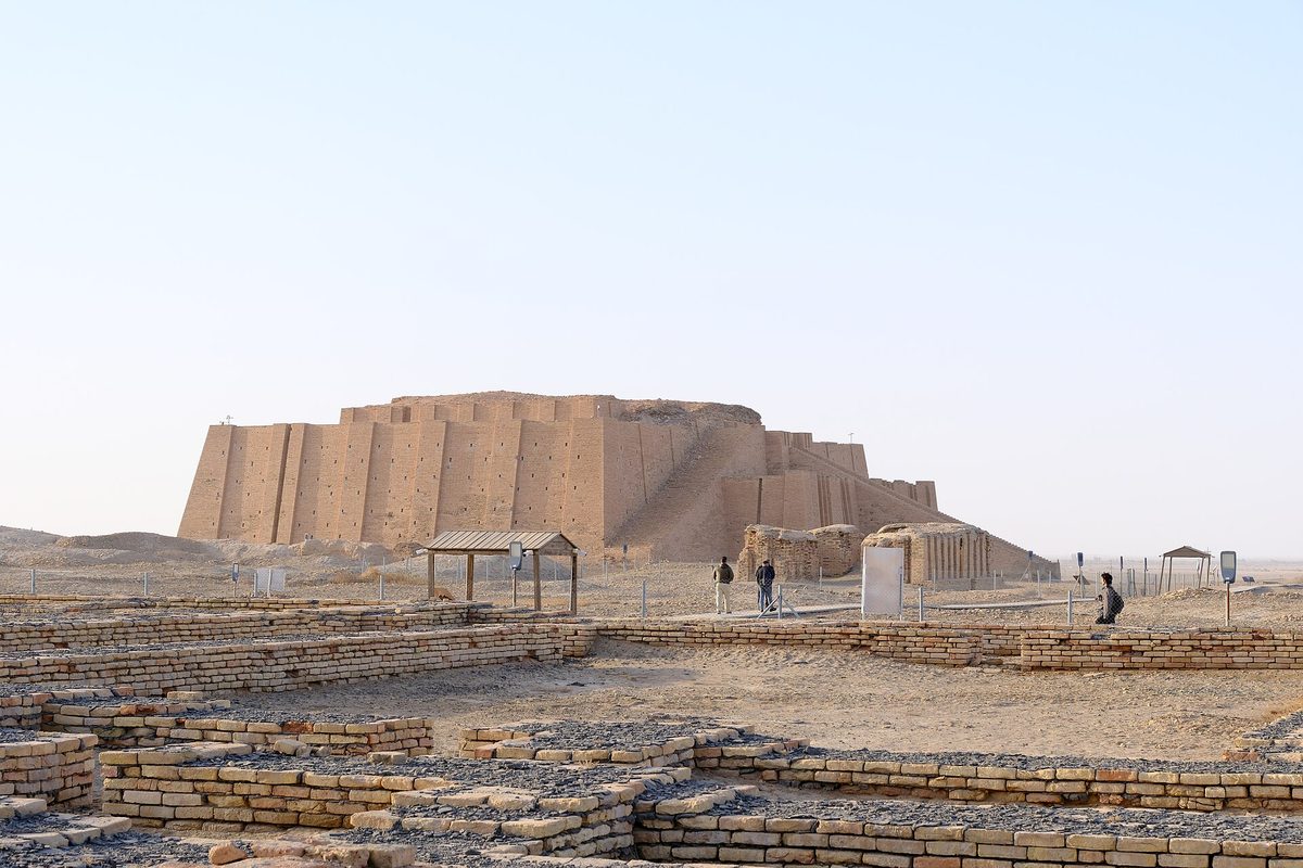
The Ziggurat of Ur
The Great Ziggurat of Ur is the south’s must-see, and the most impressive ancient monument you can easily walk up to in all of Iraq. Built around 2100 BCE by King Ur-Nammu and heavily reconstructed in the 20th century, its colossal mud-brick terraces and triple monumental staircase rise straight out of the desert near Nasiriyah, in Dhi Qar province. Beside it spreads the excavated Royal City — the “House of Abraham,” reputed birthplace of the prophet, among the mud-brick foundations.
Two practical notes for 2026. First, you can no longer climb the ziggurat’s grand staircase — it’s now fenced off to protect the structure, after years of visitors scrambling up it. You can still walk right up to the base and around the monument, which is plenty awe-inspiring. Second, the site is in the middle of a major restoration campaign — the seventh in its history — repairing the staircases and lower terraces, with work expected to wrap up around July 2026, so expect some scaffolding and fenced areas. A local guardian usually meets visitors at the gate; a small tip is customary. It pairs perfectly with the marshes for a single big day out of Nasiriyah. The full archaeological story is in our ancient Mesopotamia guide, and Ur features in our roundup of the best places to visit in Iraq.
Uruk and Eridu (for the committed)
The other two UNESCO cities are harder. Eridu (Tell Abu Shahrein), southwest of Nasiriyah, is reckoned the oldest city in the world, founded around 5400 BCE — but it’s a remote, low scatter of mounds with no facilities, reachable only by a deliberate desert detour, usually on a specialist archaeology tour combined with Ur. Uruk (Warka) — the city of Gilgamesh, where writing may first have been used — is even more remote and is generally not set up for casual visits at all. Unless you’re an archaeology devotee traveling with a specialist guide who has arranged access, treat Eridu and Uruk as names to savor rather than stops to bank on, and let the magnificent, accessible Ziggurat of Ur stand in for ancient Sumer.
Nasiriyah: gateway to Ur and the marshes
Most southern itineraries pivot on Nasiriyah, the capital of Dhi Qar province on the Euphrates. It isn’t a glamorous city and few people come for Nasiriyah itself, but its location is perfect: the Ziggurat of Ur sits just on its outskirts, the Chibayish marshes are about 90 minutes away, and the city has enough simple hotels and restaurants to make a comfortable-enough base for a night. Expect basic, functional accommodation in the 30,000–50,000 dinar range ($20–40) rather than anything polished. The classic move is to sleep in Nasiriyah, do Ur first thing in the morning before the heat, and spend the afternoon and sunset out in the marshes. Nasiriyah also carries heavy modern history — it saw fierce fighting in 2003 and was a center of the 2019 protest movement — which a thoughtful local guide can bring to life. For where to lay your head across the south, see our where to stay in Iraq guide.
Sawa Lake: a vanished wonder near Samawah
One cautionary stop, included because it tells you something true about the modern south. Near Samawah, between Najaf and Nasiriyah, Sawa Lake was for centuries a strange and beautiful sight — a self-contained saltwater lake sitting above the surrounding land, fed by underground springs, with no inlet or outlet, ringed by white gypsum banks. It was a Ramsar-listed wetland and a beloved local picnic spot.
It is essentially gone. Over-pumping of the aquifer that fed it, hundreds of illegal wells, collapsing river flows and climate change drained the lake until, in April 2022, it dried up completely for the first time in recorded history — and it has stayed a cracked, salty flat with only a residual pond ever since. I mention Sawa not as a destination but as a marker: the same water crisis that nearly killed the marshes and salted Basra’s canals took this lake entirely. If you pass nearby, it’s a sobering five-minute stop and a reminder of why visiting — and supporting — the surviving wetlands while you still can actually matters.
How to get to southern Iraq
Southern Iraq is more accessible than its remoteness suggests, with three realistic ways in. Most independent trips start in Baghdad — see our Baghdad travel guide for the capital — and head south by road or rail; pilgrims often fold the south into a holy-cities trip through Najaf and Karbala, which sit on the way down.
| Route | How | Time | Notes |
|---|---|---|---|
| Baghdad → Basra | Night sleeper train | ~8.5 hrs (overnight) | Daily, dep ~8pm; sleeper from ~$24–28 |
| Baghdad → Basra | Flight (BSR airport) | ~1 hr | Fastest; domestic + regional flights |
| Baghdad → Nasiriyah | Shared taxi / private car | ~5–6 hrs (~345 km) | Good freeway; base for Ur + marshes |
| Najaf/Karbala → Nasiriyah | Shared taxi | ~3–4 hrs | Natural add-on to a pilgrimage trip |
The Baghdad–Basra night train deserves a special mention because it’s a genuine experience and a traveler favorite. A Chinese-built, air-conditioned sleeper leaves Baghdad Central around 8pm and reaches Basra’s Al-Maqal station about 4:30am, running daily in each direction. A two-berth sleeper is about 37,000 dinars ($28) and a four-berth around 31,000 dinars ($24), with ordinary seats and a buffet car too. There’s no online booking — you buy at the station on the day of travel (the Baghdad ticket office runs roughly 9am–7pm), so go early if you want a sleeper. It’s safe, comfortable and beats an overnight drive. The full transport picture — flights, shared-taxi “garages,” apps, borders and the train — is in our getting around Iraq guide.
A southern Iraq itinerary
Here’s how I’d actually structure a southern trip, depending on how much time you have. These slot neatly into the longer national routes in our Iraq itinerary guide.
- The fast loop (2 days, from Baghdad): Drive to Nasiriyah, overnight. Day two: Ziggurat of Ur at dawn, the Chibayish marshes in the afternoon with a sunset boat trip, then back. The essential south in a tight window.
- The classic south (3–4 days): Baghdad → Nasiriyah (Ur + marshes, with an overnight in a marsh mudhif if you can) → Basra (Corniche, Old City, Shatt al-Arab, food) → Al-Qurnah’s Garden of Eden → fly or train back from Basra. The trip this guide is really built for.
- South-and-shrines (5+ days): Add Najaf and Karbala on the way down from Baghdad, turning it into a sweep through the holy cities and the deep south — a brilliant combination of living pilgrimage and ancient history. Pair it with our pilgrimage guide.
Whichever you choose, anchor the plan around two fixed points: do the marshes and Ur together out of Nasiriyah, and give Basra at least a full evening for the riverfront. Everything else flexes around the heat and the checkpoints.
Where to stay and what it costs
Accommodation in the south runs from genuinely comfortable in Basra to cheerfully basic everywhere else. Basra has a few international-standard business hotels (think waterfront five-stars in the $100–180 range) plus mid-range options from $60–130; Nasiriyah and the smaller towns are firmly in the simple-hotel bracket at $20–40; and the marsh mudhif homestay — around 140,000 dinars (about $95) for two people including the boat trip, dinner, breakfast and an overnight — is less a hotel than an experience. Our where to stay in Iraq guide covers the south city by city.
On money: Iraq is a cash economy for foreigners, and the south is no exception. Carry clean US dollars and change them into dinars as you go — in mid-2026 the dinar trades around 1,300 to the dollar officially but closer to 1,540 on the street, and paying smaller places in dinars (rather than the dollar price quoted to foreigners) often saves you 15–25%. ATMs are unreliable for foreign cards, so bring enough cash for the whole southern leg. Budget travelers manage on roughly $45–65 a day on the ground; add drivers, the boat and site tips on top. The full breakdown is in our Iraq travel cost guide.
Best time to visit southern Iraq
Let the heat decide for you. The south is comfortable to visit from roughly November to March, the only window I’d actively recommend, with December to February the most pleasant. The marshes are at their best in these cooler months too, when the birdlife peaks and a day on the water is a joy rather than an ordeal. Avoid May to September entirely if you can — Basra and the southern plains routinely top 48–50°C, the marshes shimmer with humidity, and outdoor sightseeing becomes genuinely hazardous. If a pilgrimage event like Arbaeen or Ashura overlaps your trip the holy cities en route will be extraordinarily crowded; check the dates in our best time to visit Iraq guide before you lock anything in.
Southern Iraq travel FAQ
Is southern Iraq safe to visit right now?
Western governments say no: as of mid-2026 the U.S. has Iraq at Level 4 (Do Not Travel) and the UK FCDO advises against all travel to Federal Iraq, including the south, citing terrorism, kidnapping and regional conflict. In practice, independent travelers and small groups do visit Basra, Ur and the marshes, almost always with a local guide. It’s a destination for experienced, risk-aware travelers, not a casual first trip — read our safety guide and re-check advisories before you go.
Can you visit the Mesopotamian Marshes?
Yes. The marshes are open to visitors and are the highlight of the south. You reach them from the town of Chibayish, about 90 minutes from Nasiriyah, where local boatmen run canoe trips among the reed islands and water buffalo. A guide or fixer arranges everything; permits are minimal and often unnecessary. Late afternoon into sunset is the best time, and you can stay overnight in a reed guesthouse.
How much does a marsh boat trip cost?
Reckon on around 50,000 dinars (roughly $35) for a couple of people for a two-to-three-hour boat trip with a local guide, though the most famous boatman charges about three times that. The best value comes from packages that bundle the boat, lunch, a masgouf dinner, breakfast and an overnight mudhif stay into one price — often around 140,000 dinars (about $95) for two. Always confirm what’s included before you set off, and bring cash.
What happened to the Marsh Arabs and the marshes?
Saddam Hussein drained the marshes in the 1990s as punishment after the 1991 uprising, destroying about 90% of the wetlands and scattering a population that once numbered half a million. After 2003 the marshes were partly re-flooded and people returned, but a severe drought from 2021 to 2025 shrank them again. Heavy rains in 2025–26 have revived them substantially, though the recovery is fragile.
Can you climb the Ziggurat of Ur?
Not anymore. The great staircase is now fenced off to protect the 4,000-year-old structure, and the site is undergoing a major restoration expected to finish around mid-2026. You can still walk right up to the base of the ziggurat and explore the surrounding Royal City and the “House of Abraham,” which is plenty impressive. A guardian usually meets visitors; a small tip is customary.
Where is the Garden of Eden in Iraq?
Tradition places it at Al-Qurnah, about 74 km north of Basra, where the Tigris and Euphrates rivers meet. A fenced, long-dead tree known as “Adam’s Tree” marks the supposed spot beside a small riverside park. It’s folklore rather than history, and the site is modest, but the setting at the confluence of Mesopotamia’s two great rivers makes it a worthwhile short stop from Basra.
How do you get from Baghdad to Basra?
Three ways: the daily overnight sleeper train (departs Baghdad around 8pm, arrives Basra about 4:30am, sleeper from $24–28, bought at the station on the day); a one-hour flight to Basra International; or a five-to-seven-hour drive by shared taxi or private car down Freeway 1. The train is a memorable experience and a traveler favorite. See our transport guide for details.
How hot does Basra get?
Dangerously hot. Basra recorded Iraq’s all-time high of 53.9°C (129°F) on 22 July 2016, and summer temperatures regularly sit near 50°C from May to September with high humidity off the Gulf. This is why the only sensible time to visit southern Iraq is the cooler half of the year, roughly November to March.
Is southern Iraq worth visiting?
If you’re already the kind of traveler who’d consider Iraq, absolutely — the south holds the country’s single most unique experience (the marshes), its most important ancient site (Ur), and a riverside city, Basra, with a character all its own. It’s raw, hot and logistically demanding, and it carries real safety caveats. But for ancient history, living culture and genuine off-the-map travel, nowhere in the country rewards the effort more.
Do you need a guide for southern Iraq?
You don’t strictly need one, but I’d strongly recommend it. A local guide or driver solves the marsh-boat logistics, the language barrier, the constant checkpoints and the safety unknowns in one move, and turns Nasiriyah’s history and the marsh culture from scenery into stories. Many travelers arrange a driver-guide for the whole southern leg; it’s the single best money you’ll spend down here.
Final thoughts: the south is the reward
Southern Iraq asks more of you than anywhere else in the country — more heat, more planning, more comfort with uncertainty — and it gives more back. This is where civilization began, where a 5,000-year-old way of life still floats among the reeds, and where the rivers of Eden actually meet. The marshes alone are worth the journey, and the fact that you’ll likely have Ur almost to yourself is a quiet privilege that won’t last forever.
Go in the cool months, go with a good guide, go with realistic expectations about the heat, the water crisis and the safety picture — and go with an open heart, because the hospitality down here, in the poorest and oldest corner of Iraq, is something you’ll be telling people about for years. When you’re ready to build the wider trip, start with our complete Iraq travel guide, sort the paperwork in the visa guide, read the situation honestly in our safety guide, and map your days with the itinerary planner. The deep south will still be there when you arrive — go while the water’s back.
Sources & further reading: the UNESCO inscription details for “The Ahwar of Southern Iraq: Refuge of Biodiversity and the Relict Landscape of the Mesopotamian Cities” (World Heritage List no. 1481, inscribed 2016) via UNESCO; the 2026 marsh recovery figures (submerged marshland rising to roughly 32–36% after the 2025–26 rains) via Al Jazeera and Reuters reporting from Chibayish, April–May 2026; the history of the marshes’ draining and the Marsh Arabs via Wilfred Thesiger’s “The Marsh Arabs” and Human Rights Watch; the Ziggurat of Ur restoration and access status via 2026 reporting on the seventh restoration campaign; Basra’s 53.9°C temperature record (22 July 2016) and the 2018 water-crisis hospitalizations via meteorological and Human Rights Watch sources; Sawa Lake’s 2022 disappearance via the Iraqi Ministry of Water Resources and Copernicus satellite monitoring; the Baghdad–Basra train schedule and fares via seat61.com (updated 2026); and current safety framing via the U.S. State Department (Level 4, Do Not Travel) and the UK FCDO (advises against all travel), checked June 2026. Conditions, prices and the water situation in southern Iraq change quickly — treat every figure here as a researched starting point and confirm the current picture before you travel.
Photo credits: The Mesopotamian Marshes near Suq al-Shuyukh by Pharling (CC BY-SA 4.0); the interior of a reed mudhif guesthouse by Hassan Al-Jarrah (CC BY-SA 4.0); a young herder and water buffalo in the Chibayish marshes by Alli Khalil (CC BY-SA 4.0); the Basra corniche on the Shatt al-Arab by Lordali91 (CC BY-SA 3.0); the Great Ziggurat of Ur near Nasiriyah by Alli Khalil (CC BY-SA 4.0); and Marsh Arabs in a mashoof canoe by Hassan Janali / U.S. Army Corps of Engineers (public domain). All via Wikimedia Commons.
Last updated: June 2026. We keep this guide current — if something has changed on the ground in the south, tell us and we’ll update it.