Last updated: August 2026. FCDO regional wording, Ministry of Health fever figures and Arbaeen crowd numbers all re-checked against sources published in July and August 2026.
Fly into Basra in November and the first thing you notice is water. Not the desert everyone warns you about — water, in canals and creeks and the wide brown sweep of the Shatt al-Arab. The second thing is how little of the security theatre you were braced for ever turns up: a couple of checkpoints, a bored soldier glancing at a passport, a city getting on with itself. Basra’s risk profile only makes sense against the national safety picture.
So, honestly: is Basra safe? For a foreign visitor moving around the city centre in daylight with a local driver or guide, street-level Basra is calmer than its reputation and calmer than Baghdad. The dangers that actually put travellers in hospital in southern Iraq are not the ones on the news. They are heat, water, road accidents, being close to a dispute that has nothing to do with you, and a tick-borne virus that is having its worst year on record in exactly the province most people drive through to reach the marshes. Every Western government advises against travelling here — the UK says all but essential travel to Basra, Dhi Qar, Najaf, Karbala, Maysan, Al-Muthanna and Al-Qadisiyah, and against all travel to a handful of specific pockets — and that advice invalidates most travel insurance, which is the consequence almost nobody spells out.
This guide separates the two questions that usually get mashed together: what the advisories say and why, and what actually goes wrong for people in the south. It covers the province-by-province advisory map including the parts of Basra that are treated differently from the rest, the tribal and militia dynamics that make the south a genuinely different risk profile from the north, the heat, the water, the current haemorrhagic fever outbreak, what visiting Najaf and Karbala involves as a non-Muslim, what Arbaeen does to the whole region, and what boat trips in the marshes really require. It is a companion to our wider Iraq safety guide and to the regional southern Iraq travel guide, which covers what there is to see once you have decided to go.

The short answer
If you are here for one thing — is Basra safe, yes or no — this is the compressed version. Everything below it is the reasoning, the caveats and the things that are specific to the south rather than to Iraq generally.
| Question | Answer |
|---|---|
| Is Basra safe to walk around? | City-centre Basra in daylight, yes, and foreigners are a curiosity rather than a target. Alone at night, in the far suburbs or near oil and port infrastructure, no |
| What does the FCDO say? | All but essential travel to Basra province; all travel within 5km of the Iran border, and to Highways 1 and 8 and the Safwan crossing being singled out by name |
| Is Najaf safe? | Among the most heavily policed places in Iraq, and street crime is close to non-existent. The constraints are social and procedural, not violent |
| Biggest actual risk? | Heat in summer, road accidents year round, and proximity to disputes you are not part of |
| Health risk to take seriously? | Crimean-Congo haemorrhagic fever — 313 cases and 24 deaths in Iraq in 2026, Dhi Qar worst hit |
| Can I drink the water? | No. Bottled only, including for teeth. Basra’s tap supply is saline and periodically contaminated |
| Do I need a guide? | Not legally, but practically yes for the marshes, and it makes checkpoints far easier everywhere else |
| Will insurance cover me? | Almost certainly not on a standard policy, because of the advisory. Check before you book anything |
What the advisories actually say about southern Iraq
Most articles asking whether Basra is safe quote a single line about Iraq and stop. The UK advice has not been a blanket warning for some time; it was regionalised, and the version current on 7 August 2026 was last updated on 22 July. The distinctions matter, because they are the difference between a whole province and a five-kilometre strip, and because insurers read the wording literally.
| Area | FCDO position (July 2026) |
|---|---|
| Basra province (general), incl. Highways 1 and 8 and the Safwan–Kuwait crossing | Against all but essential travel |
| Within 5km of the Iran border in Basra, Maysan and Wasit | Against all travel |
| Within 5km of the Saudi and Kuwaiti borders | Against all travel |
| Dhi Qar, Maysan, Al-Muthanna, Al-Qadisiyah | Against all but essential travel |
| Najaf and Karbala provinces | Against all but essential travel |
| Babil province, except Jurf al-Sakr town | Against all but essential travel |
| Jurf al-Sakr town, Babil | Against all travel |
The United States is blunter and does not regionalise at all. Iraq sits at Level 4, Do Not Travel, reissued on 2 March 2026 with no softening: “Do not travel to Iraq for any reason.” On the same date the State Department ordered non-emergency US government staff out of the country, and its personnel in Baghdad remain barred from using Baghdad International Airport. The advisory’s line about leaving DNA samples with your medical provider gets mocked online; it is a real instruction, aimed at making identification possible if a kidnapping ends badly, and it tells you something about the scenario the US is planning around rather than the scenario a tourist is likely to meet.
The Basra exception nobody quotes properly
Two things in the Basra wording repay attention. The first is the five-kilometre Iranian border strip, which is an “all travel” zone rather than “all but essential” — that band runs along the eastern edge of the province, through the Shalamcheh crossing area and the old Faw peninsula battlefields, and it has been active ground for smuggling, unexploded ordnance and, since 8 July 2026, cross-border strikes.
The second is that the FCDO names roads. Highway 1 and Highway 8 are the arteries running north out of Basra towards Nasiriyah, Amara and eventually Baghdad, and the Safwan crossing is the road route to Kuwait. Naming them is unusual and it signals what the risk actually is: not the city, the roads. Long, flat, fast highways with heavy truck traffic, informal checkpoints, and occasional closures when a tribal dispute spills onto the carriageway. If you take one practical thing from the advisory, it is that the driving between southern cities is riskier than the walking within them, which is the inverse of what most first-time visitors assume.
Jurf al-Sakr, the town on the Karbala road you cannot enter
Jurf al-Sakr — renamed Jurf al-Nasr — is a town in Babil province about 60km south-west of Baghdad, and it is the one place in the south the UK singles out for an outright “against all travel” designation. It has been closed to its own residents since October 2014, when the area was cleared of Islamic State fighters and the population was told the closure would last eight months. More than a decade on, parliamentary estimates put the number of people still barred from returning at over 120,000. Reporting from Iraqi and regional outlets consistently describes the town as a closed military zone controlled by Kataib Hezbollah rather than by the federal state.
It matters to visitors for one geographical reason: it sits on the approaches between the Fallujah–Baghdad axis and Karbala. Nobody is going to accidentally wander into it — it is fenced, guarded and unmistakable — but if you are routing between Baghdad and Karbala, or looking at a map and wondering why a road that appears to exist cannot be driven, this is the answer. Take the route your driver takes and do not improvise a shortcut. That is good advice everywhere in Iraq; here it is specific.
What “all but essential travel” does to your insurance
This is the single most practical consequence of the advisory picture and it gets buried at the bottom of most safety articles. A standard travel insurance policy voids cover for the period you spend in an area your own government advises against travelling to. In southern Iraq that is every province, without exception. It is not a technicality that gets waved through; medical evacuation from Nasiriyah or Amara is a five-figure sum and the insurer will check the advisory in force on the date of the incident.
Specialist policies exist that cover travel against government advice, they cost several times a normal premium, and they normally require you to declare your itinerary. Our guide to travel insurance for Iraq covers the mechanics and the questions to ask an underwriter. Sort this before you book flights, because the answer sometimes changes the trip.
Is Basra safe? The real risk profile in the south
Here is the core of it, and the reason a single national safety rating for Iraq is close to useless. The south’s risk profile is not a milder version of the north’s. It is a different profile: less terrorism, more of everything else.
Terrorism is not the main risk here
The Islamic State insurgency that still generates attacks in Kirkuk, Salah al-Din, Diyala and rural Anbar barely operates south of Baghdad. The population is overwhelmingly Shia, the terrain is flat, wet and heavily settled, and the security apparatus is dense. That is why the FCDO’s “against all travel” designations cluster in the north and the west while the south is mostly “all but essential”. If you have read our guides to whether Mosul is safe or Baghdad is safe, you are carrying a mental model built around bombings and checkpoints. Put it down for the south. It does not describe what happens here. When someone asks is Basra safe from terrorism, the honest answer is that this is not the threat the province struggles with.
What replaces it is a mix that Western risk language handles badly, because none of it is aimed at you and all of it can involve you.
Weapons, tribal disputes and the “degga” problem
Southern Iraq has an enormous quantity of light and medium weaponry outside state control, concentrated in exactly the provinces travellers pass through: Maysan, Dhi Qar and Basra. Combined with unresolved feuds over land, water and status, and weak enforcement of weapons law, this produces a steady drumbeat of armed disputes between families and tribes. In November 2025 a land dispute near Ali al-Gharbi, north of Amara in Maysan, left seven dead and six wounded. In February 2026 a dispute in Amara’s Um Ghurba area escalated into gunfire in a residential street. There is a specific local practice, degga ashairiya, of firing on a house to deliver a warning; in December 2025 the Iraqi government announced it would prosecute tribal conflicts and degga under anti-terrorism legislation, which tells you both that the problem is serious and that the state has been struggling to contain it.
Foreigners are not targets in any of this. That is genuinely important and it is why the south feels as relaxed as it does day to day. But you can be near it. Disputes close roads without warning, sometimes for hours, and the sound of automatic fire at a wedding, a funeral or a feud is common enough that you should have a plan that is not “go and look”. The plan is: get inside, stay away from windows, let your driver or host decide when to move. Dhi Qar has seen a real decline in tribal violence over the past two years after a concerted police campaign and dozens of arrests, which is worth saying because it is the direction of travel — but the baseline is still high by any standard you are used to.
Militias, checkpoints and who is actually stopping you
You will pass a lot of checkpoints in the south. Most are unremarkable: a glance at a passport, a question about where you are going, occasionally a phone call to somebody senior, and you are through. Two checkpoints on the way into Basra city is a typical count. There is no requirement for a military escort anywhere on the southern circuit, and the old rule about needing a local sponsor has gone.
What is different in the south is that not every armed group at a checkpoint is straightforwardly state police or army. Popular Mobilisation units, some of them Iran-aligned, hold real territory and real authority, and the uniforms do not always tell you which is which. In practice this changes little for a visitor — the same passport, the same politeness, the same answers — but it changes two things. First, it makes having a local driver or guide who can read the situation genuinely useful rather than a luxury; they will know whose checkpoint it is and what tone to take. Second, it means you should not argue, film, or get out of the vehicle at a checkpoint under any circumstances. A registered guide can also arrange the permissions occasionally needed for sensitive sites; a good Iraq tour operator handles this as a matter of routine.
Protest and civil unrest
Basra has one of the most sustained protest histories in Iraq. The grievances are old and unresolved: electricity that fails in the hottest months, undrinkable water, unemployment in a province that produces the overwhelming majority of the country’s oil revenue. The 2018 wave saw government buildings and party offices burned. The 2019–20 movement ran for months. Smaller flare-ups have recurred every summer since, and 2026 has added a new pressure — declining oil revenue and reduced exports through the Basra terminals amid the regional escalation, which makes the service improvements people are demanding harder to fund.
For a visitor this is manageable but not ignorable. Protests concentrate in known places and are usually announced on local social media a day or two ahead; security forces have used tear gas, water cannon and live fire in the past, and the casualty figures from 2019 were substantial. Do not go to look. If you are in Basra in July or August and something starts, your hotel and your driver will know before you do, and the correct response is to change your day rather than photograph it.

Crime and kidnapping
Ordinary street crime against foreigners in the southern cities is low. Pickpocketing exists in crowded markets and around the shrine districts during religious seasons, as it does anywhere with dense crowds. Violent robbery of visitors is rare enough that it does not shape the way people travel.
Kidnapping is the risk that governments emphasise, and the honest framing is that it is real but heavily concentrated on a specific profile: people connected to oil, security, contracting and NGOs, who are known to have institutional money behind them, who move on predictable routes at predictable times. An independent traveller staying two nights and moving on does not fit that profile. That is not a guarantee, and it is precisely why the advice about routine — vary your times, do not post your location in real time, do not broadcast your hotel — is worth following even though it feels paranoid on day one.
Heat: the part of “is Basra safe” that actually hospitalises people
This is the risk that puts visitors in a clinic, and it is the one most safety pages treat as a footnote about sunscreen. Basra holds Iraq’s all-time temperature record of 53.9°C, set in July 2016, which puts it among the highest air temperatures ever reliably measured anywhere on Earth. This is not a freak. In July 2025 both Basra and Amara hit 53.0°C, and on 28 July that year Basra International Airport was recorded as the hottest place on the planet at 51.8°C, with Iraqi cities occupying eleven of the world’s fifteen hottest spots. Southern provinces including Basra, Dhi Qar, Maysan and Karbala routinely suspend public work when it goes over.
| Period | Typical daytime high in Basra | What it means practically |
|---|---|---|
| November–March | 18–27°C | The visiting season. Comfortable all day; evenings can need a jacket |
| April and October | 30–38°C | Workable with a midday break. Marshes still pleasant early and late |
| May and September | 40–46°C | Sightseeing limited to early morning. Dehydration risk is real |
| June–August | 45–53°C | Genuinely dangerous outdoors. Power cuts make indoors dangerous too |
The compounding factor is electricity. Southern Iraq’s grid fails hardest exactly when demand peaks, and a hotel without a working generator in August is not a place you want to be at three in the morning. Ask about the generator when you book — it is a more useful question than the star rating, and our guide to where to stay in Iraq goes into what the accommodation tiers actually deliver. Plan around the season rather than fighting it: the best time to visit Iraq is November to March almost everywhere, and in the deep south that window is narrower and less negotiable than in Kurdistan. Bring electrolyte sachets, a wide hat and more water capacity than feels necessary; our Iraq packing list has the full kit.
Water, sanitation and the shadow of 2018
Do not drink the tap water anywhere in southern Iraq. That instruction is standard for the whole country, but in Basra it carries specific history. In the summer of 2018 at least 118,000 people were admitted to hospital in Basra province with symptoms doctors linked to water quality, in what Human Rights Watch later documented as a failure of management, infrastructure and pollution control rather than a single contamination event. Investigators identified probable causes ranging from norovirus and giardia to E. coli and metals from sewage and industrial discharge, alongside oil spills into the Shatt al-Arab and pipelines releasing waste into the waterway.
The underlying problem has not gone away. Upstream damming on the Tigris and Euphrates and their tributaries, in Turkey and Iran, has cut freshwater flow so far that seawater from the Gulf pushes up the Shatt al-Arab. Salinity has destroyed a large majority of Basra’s farmland. In February 2026 the Al-Mashrah river in Maysan hit record low levels, and by 24 February more than 10,500 families in Dhi Qar had been displaced by water shortage. This is the context for the protests, and it is also the reason a bottle of water in the south is a health decision rather than a preference.
Practically: bottled water only, including for brushing teeth; no ice unless you are somewhere that clearly makes it from bottled water; be careful with salads and unpeeled fruit outside established restaurants. Cooked food from busy places is fine and southern Iraqi cooking is one of the pleasures of the trip — our guide to Iraqi food covers what to look for, including the river fish grilled as masgouf that Basra does particularly well.
Crimean-Congo haemorrhagic fever: the south’s live health story
This is the fact that no competing safety article carries, and it is the one most relevant to anyone heading for the marshes or the rural south. Iraq is in the middle of an active Crimean-Congo haemorrhagic fever outbreak. As of the Ministry of Health bulletin reported on 6 August 2026, the country has recorded 313 confirmed cases and 24 deaths in 2026. Dhi Qar province — the province that contains Nasiriyah, the ziggurat of Ur and the Chibayish marshes — is the worst affected in the country, with 119 confirmed cases and 9 deaths. The most recent week added 14 cases and one death, those in Ninawa in the north.

How you would actually catch it
Proportion matters here, so be clear about the transmission routes. CCHF is spread by the bite of infected ticks, chiefly Hyalomma species, and by direct contact with the blood or tissue of infected livestock — sheep, goats, cattle, buffalo — particularly at the moment of slaughter or butchering. It also passes person to person through contact with the blood or bodily fluids of a sick patient, which is why healthcare workers appear in the case numbers. The case fatality rate is high, up to around 40% in reported series.
What it is not is a food-borne illness. Eating a cooked kebab in a Nasiriyah restaurant does not put you at risk. Sitting in a hotel in Basra does not put you at risk. The people getting infected in Iraq are, overwhelmingly, herders, butchers, abattoir workers, veterinary staff and their families. The reason it belongs in a travel safety article at all is that a slice of the southern itinerary overlaps with that world: livestock markets, farm visits, buffalo-herding households in the marshes, and the sheep pens you walk past in a village.
The practical precautions
None of this is elaborate. Do not visit livestock markets or abattoirs. Do not handle animals, and specifically do not touch buffalo, sheep or goats even when a friendly host offers. Do not attend or watch a slaughter. In rural and marsh areas, wear long sleeves and long trousers in light colours so ticks are visible, use a DEET or picaridin repellent on skin and treat clothing with permethrin if you can, and check yourself for ticks at the end of any day spent in vegetation or around animal pens. If you find an attached tick, remove it with fine tweezers close to the skin rather than crushing it. Any fever within two weeks of a rural stay in Iraq is worth a doctor’s attention and worth telling them where you have been — CCHF is not on most Western clinicians’ radar and the travel history is what triggers the test.
Standard vaccination advice for Iraq still applies on top of this: routine immunisations up to date, hepatitis A and typhoid recommended, a polio booster commonly advised, and no yellow fever requirement unless you arrive from or transit more than twelve hours in a yellow-fever-risk country. Sort this at a travel clinic six to eight weeks out, alongside the Iraq entry requirements paperwork.
Is Najaf safe? The pilgrimage cities are their own category
Najaf and Karbala do not behave like the rest of the country and they should not be assessed with the same instincts. These are cities whose entire economy and governance revolve around protecting religious sites that receive tens of millions of visitors a year. Security is dense, layered and competent: vehicle exclusion zones around the shrines, body and bag searches at multiple rings, and a permanent presence of shrine security in addition to federal police. Street crime is close to non-existent. As a physical-safety proposition, the shrine districts of Najaf and Karbala are among the most controlled public spaces in the Middle East.

What is stricter here is social. These are conservative cities where religious observance is the organising fact of daily life. Modest dress is not a suggestion. Women should expect to wear an abaya and headscarf in and around the shrines — they are usually available to borrow at the entrance — and men should cover shoulders and knees, with long trousers rather than shorts everywhere in the shrine districts. Public displays of affection, alcohol and loud behaviour are all badly out of place. Photography of the shrine exteriors and courtyards is generally fine; cameras, and often bags, are not permitted inside the inner sanctums, and there are lockers or minders at the gates for exactly this.
Non-Muslim access, honestly
Non-Muslims do visit the shrines at Najaf and Karbala, including the interiors, and travellers report being welcomed rather than tolerated. But access is not a fixed rule you can look up and rely on. It varies by shrine, by gate, by the individual on duty, and by the period — during Muharram, Ashura and Arbaeen, or in a moment of political tension, the answer can be different from the one a blogger got two years ago. The reliable approach is to go with a local guide who can ask on your behalf, dress correctly before you turn up, and accept whatever answer you get without argument. Our guide to pilgrimage travel in Iraq goes into the shrine circuit in more depth, and the wider piece on Iraqi culture and etiquette covers the behavioural ground.
Arbaeen: what 22 million people does to a region
Arbaeen fell on 5 August in 2026. More than 22 million people entered Karbala for it, including roughly 5 million from outside Iraq — it is the largest annual gathering of people anywhere on Earth, and it does not resemble a festival so much as a national mobilisation. Millions walk the roughly 80km from Najaf to Karbala on foot over several days, along a route lined with mawakib, free service tents offering food, water, foot massages and floor space to sleep.

If you are in Iraq during the two weeks either side of Arbaeen, understand what changes. Hotel rooms in Karbala and Najaf are gone months in advance and prices elsewhere in the south rise sharply. Roads between Baghdad, Najaf and Karbala carry closures, diversions and multi-hour queues. Domestic flights fill. Najaf airport handles a surge of international pilgrims and immigration queues stretch. Crowd density around the shrines is extreme, and crush injuries and heat casualties are the recurring causes of harm, along with road accidents involving pilgrim buses. The state deploys enormous security resources and the event usually passes without a mass-casualty attack, but crowd physics is its own hazard.
It is also, by every account, one of the most extraordinary things a traveller can witness, and the hospitality shown to strangers along the route is real. If that appeals, go deliberately, with accommodation locked in, with a guide, with a plan for heat, and with the acceptance that you will move at the crowd’s pace and not your own. If it does not appeal, simply schedule around it — check the date each year, since it moves with the lunar calendar, roughly eleven days earlier annually.
The marshes: boats, distance and being far from a hospital
The Ahwar — the Mesopotamian Marshes, UNESCO-listed since 2016 — are the reason many people come south at all, and the safety questions they raise are almost entirely non-political. Most trips launch from Chibayish in Dhi Qar province, in a mashoof, the long wooden canoe now usually fitted with an outboard. Reported rates run in the region of 25,000–35,000 IQD per boat per hour, which is roughly $19–27; treat that as a guide rather than a quote, since it varies with the season, the boatman and whether you booked through an operator.
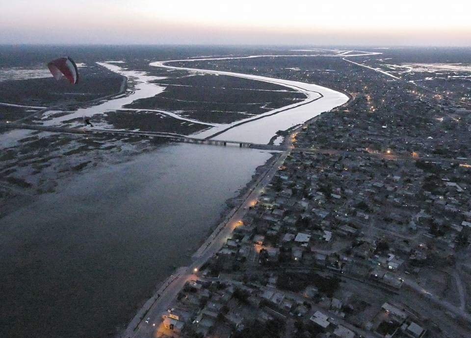
The specifics worth knowing before you get in a boat. Life jackets are frequently not carried; ask in advance and, if it matters to you, say you will not go without one. The channels are shallow but the water is opaque and the reed beds are disorienting — do not swim, both for contamination reasons and because getting separated from a boat here is serious. Sun exposure on open water is brutal and there is no shade for hours at a time. Insects are heavy at dawn and dusk, which is also when the light is best, so repellent is not optional. And the practical point that underlies all of it: the nearest hospital with real capability is in Nasiriyah, an hour or more away from most marsh locations once you add the boat leg, and mobile signal in the channels is inconsistent. A local Iraqi SIM card helps but does not solve it. Whatever happens out there, the response time is measured in hours.
The honest state of the marshes
It is tempting to write about the Ahwar as an untouched Eden and every second travel page does. That is not what you will see. These wetlands have been drained, re-flooded, and then hammered by a decade of drought and upstream water abstraction. The recovery is genuinely under way — reporting in 2026 put the proportion of submerged marshland back up to somewhere between 32% and 36%, against no more than 8% at the worst of the past five years, with buffalo herders and fishermen returning to areas that had been abandoned. That is real good news and it is also a long way from restoration.
What that means for a visitor is partly practical: water levels determine which channels are navigable and which villages can be reached, and a route that worked last spring may not work this autumn. It also means the people you meet are living through an ecological collapse and a partial reprieve, not performing a heritage lifestyle for visitors. Ask before photographing anyone. Pay properly. If you want the deeper history of this landscape and the Sumerian cities beside it, our guide to ancient Mesopotamia covers Ur, Eridu and Uruk, all within reach of the same base.
Basra city: what it is actually like on the ground
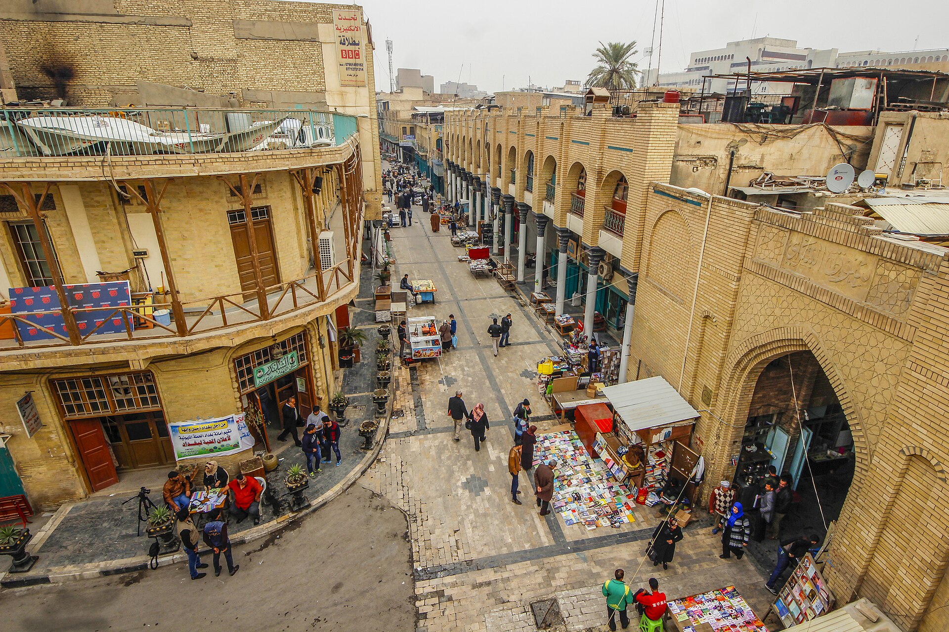
Basra is an oil town with an old soul. The Shatt al-Arab runs through it, formed where the Tigris and Euphrates meet at Al-Qurnah upstream, and the corniche along it is where the city gathers in the evening — families, tea, grilled fish, the occasional wedding convoy. Behind it, the Ashar quarter holds what survives of the Ottoman-era merchant houses with their carved wooden shanasheel balconies, some restored, many collapsing, all of it photogenic in a way that feels uncomfortable if you think about it too long. The Basra Museum, in one of Saddam Hussein’s former palaces on the waterway, is genuinely good and worth the sometimes fiddly business of getting through the gate.
As a foreigner you will be conspicuous and, in the main, this works in your favour. People will want to talk, to feed you, to photograph you. That warmth is not a security assessment, though. Behind the corniche the city is an oil town, and the horizon flares at night. The practical answer to is Basra safe on foot is narrow and easy to follow: walk the old city and the canal district in daylight and preferably with someone local who knows which lanes are lived-in and which are derelict; do not photograph checkpoints, police stations, government buildings, port facilities, oil installations or anything with a fence and a guard, of which Basra has a great deal; keep away from the Umm Qasr port road and the border approaches; and treat the far southern suburbs and anywhere near the oil fields as off the list.
Alcohol is worth a note. Basra historically had a more relaxed drinking culture than most of Iraq, but licensed sales have tightened and the legal position has shifted; do not assume, do not carry it, and do not drink in public. Getting between cities is its own subject — the overnight train from Baghdad to Basra, shared taxis, and domestic flights all have different risk and comfort profiles, covered in our guide to getting around Iraq.
Women, solo travellers and other specifics
Women do travel independently in southern Iraq and report being treated with a mixture of curiosity and heavy protectiveness rather than harassment. The constraints are social: cover arms and legs, carry a scarf everywhere and use it in and around shrines and in conservative neighbourhoods, expect to be seated separately in some restaurants, and expect that a woman travelling alone will prompt a lot of questions. Staring is common; catcalling is not. Shared taxis where you are the only woman are best avoided in favour of a booked car.
Solo travel in the south is more constrained than it is in the north, where Kurdistan’s safety picture and its bus network both make independent movement easier. Down here the logistics assume a driver — the marshes and the archaeological sites are not reachable on public transport in any practical way. Most independent travellers end up hiring a car and driver by the day, which is also the answer to most of the checkpoint and language friction. Our guide to solo travel in Iraq covers the trade-offs, and what a trip to Iraq costs has current day rates.
LGBT travellers should know that same-sex relations are criminalised in Iraq under legislation passed in 2024, with substantial prison terms, and that southern Iraq is socially conservative even by national standards. Discretion is not optional. Dating apps are monitored and have been used in entrapment.
A southern Iraq safety checklist
Almost every honest answer to is Basra safe, or to the same question about Najaf, Nasiriyah or the marshes, comes down to preparation rather than luck. This is the list we would actually work through.
| Before you go | On the ground |
|---|---|
| Read the current FCDO regional wording, not a summary of it | Move between cities in daylight; avoid Highways 1 and 8 after dark |
| Get a policy that covers travel against advice, or accept you have none | Never photograph checkpoints, ports, oil sites or security personnel |
| Register with your embassy if it offers the service | No livestock markets, no animal handling, no watching a slaughter |
| Travel clinic: hep A, typhoid, polio booster, routine | Bottled water only, including for teeth. No ice from unknown sources |
| Book November to March; assume summer is not viable | Long sleeves and repellent in the marshes; tick check every evening |
| Arrange a driver or guide for the marshes and Ur at minimum | Ask about life jackets before boarding a mashoof |
| Check the Arbaeen date and decide deliberately | If a protest or a dispute starts, go indoors and change your plans |
Frequently asked questions
Is Basra safe at night?
The corniche and the busier commercial streets stay lively into the evening and people do walk them, usually in company. What changes after dark is everything outside that: unlit lanes in the old city, the outer suburbs, and above all the highways, where night driving is the single riskiest thing most visitors do in the south. As a rule, be back at your hotel or in a car with a driver you know once it is properly dark.
Is Basra safe for tourists right now?
Street-level Basra is safer than most people expect and foreigners are not targets, but every Western government advises against travel to the province and that advice is based on militia activity, unrest, kidnapping risk and the border areas rather than on street crime. Practically, most visitors who go with a local driver and stick to the city centre, the corniche and the museum have an uneventful time. Whether that risk is acceptable is your call, not ours.
Is Najaf safe for non-Muslim visitors?
Yes, in terms of physical safety — the shrine districts are among the most heavily secured public spaces in the country and violent crime against visitors is very rare. Access to shrine interiors for non-Muslims is possible but not guaranteed and varies by gate and by period, so go with a guide who can ask on your behalf and dress conservatively before you arrive.
Is southern Iraq safer than Baghdad or Mosul?
In terms of terrorism, yes, clearly — Islamic State activity is concentrated in the north and west. In terms of unrest, armed disputes and militia presence, the south has its own problems that Baghdad does not have to the same degree. It is a different risk profile, not a lower one across the board.
Can I visit the marshes on my own?
You can, but it is impractical. There is no public transport that reaches the launch points usefully, boatmen mostly do not speak English, and negotiating a mashoof and a route without Arabic is difficult. Almost everyone goes with a guide or a driver arranged in Nasiriyah or Chibayish.
What is the risk of Crimean-Congo haemorrhagic fever for a traveller?
Low for a normal itinerary, and not negligible if you plan to handle animals or visit livestock markets. Iraq recorded 313 cases and 24 deaths in 2026 to early August, with Dhi Qar province worst affected. Transmission is by tick bite and by contact with the blood or tissue of infected livestock, so avoiding animal contact and using tick precautions in rural areas removes almost all of the exposure.
When is the worst time to visit southern Iraq?
June through August. Temperatures over 50°C are normal, power cuts are frequent when demand peaks, protests historically flare in the heat, and outdoor sightseeing becomes genuinely hazardous. November to March is the practical window.
Do I need a different visa for the south?
No — southern Iraq is federal Iraq, so the federal e-visa applies, currently around US$114 for most nationalities since visa on arrival was suspended in March 2025. What does not work is a Kurdistan Region visa: it is a separate regime and travellers have been turned back trying to come south on one. Our Iraq visa guide sets out both.
Is it safe to travel by road between Basra, Nasiriyah and Najaf?
It is done routinely and most journeys are uneventful, but road accidents are the most common serious incident involving visitors in Iraq, and the FCDO names Highways 1 and 8 specifically. Travel in daylight, use a driver rather than driving yourself, insist on seatbelts, and do not schedule a leg that will end after dark.
Final thoughts
The question in the title has a shorter answer than the article suggests. Is Basra safe? Safer than you think in the way you were worried about, and more dangerous than you think in ways you had not considered. The heat will hurt you before a militia does. The water will make you ill before a bomb does. The likeliest thing to end your trip badly is a road accident on a highway between two cities you enjoyed.
What the south has going for it is that almost nobody is there. Ur without a coach party. A marsh at dawn with three people in it. A city where being a visitor still means something to the people you meet. That is worth a great deal, and it is also a reason to be scrupulous about the things that are genuinely within your control — the season, the driver, the water, the animals, the insurance. Most of what makes southern Iraq safety difficult is unusually amenable to preparation, which is not something you can say about everywhere.
If you decide it is a yes, the next steps are the boring ones that make it work: pin down the season and route with our Iraq itinerary planner, read the country-level picture in the complete Iraq travel guide, and see what else is in reach in the best places to visit in Iraq. And go with the advisory in front of you rather than behind you — read it, understand what it is describing, and make the decision yourself.
Photo credits
Shanasheel house on Basra’s Al-Ashar canal — Clemens Schmillen (CC BY-SA 4.0). Shrine of Imam Ali, Najaf — Goudarz.memar (CC BY-SA 4.0). Karbala during Arbaeen — U.S. Navy Petty Officer 1st Class Denny C. Cantrell / U.S. Department of Defense (public domain). Marsh household with buffalo and mashoof — Taisir Mahdi (CC BY-SA 4.0). Chibayish from the air — رديف بلال / Radeef Bilal (CC BY-SA 4.0). Basra corniche at night — Abdulsalam Al Dabbagh (CC BY-SA 4.0). All images via Wikimedia Commons.